
What was village life like in Norwich after settlement? What did they do for food, clothing, and shelter? How and where did they travel? The James Whitelaw maps of 1796 and 1810 provide a window into that world. These maps show the major buildings in each Vermont community.

Begin by providing your students with a visual image of life at settlement. One possible image is Thomas Cole’s painting, A Home in the Woods. While it is romanticized, it still provides the types of details that students need to “enter” into the Whitelaw maps. Use visual thinking strategies to gather details students see in the picture. Categorize those details into “food,” “clothing,” and “shelter.”

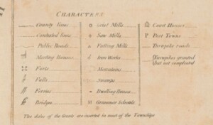
note: this map key will be in better resolution at the link to the full map
- Where are the churches and other large public buildings located?
- Where are the mills and factories located?
- What can you see on this map that would help settlers in your town make their cloths?
- What can you see on this map that would help settlers in your town build their homes?
- What can you see on this map that would help settlers in your town bake their bread?
- Where do the roads go?
- What might you conclude about your town from this map?
- What questions do you now have?